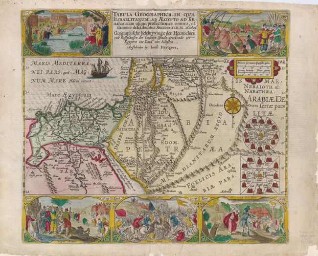
Title:
“Tabula Geographica, In Qua Israelitarum, Ab Aegypto Ad Kenahanaeam usque profectiones omnes, et stationes describuntur Auctore D.R.M. Mathes”
Map Maker:
Plancius/Hartgers
This fine copper engraved map of the region surrou... (full text available to subscribers)
| Item Detail |
| |
| |
MapMaker: |
Plancius/Hartgers
|
|
| |
| |
Subject: |
Holy Land and Egypt |
|
| |
Period/Size: |
1650 / 11.5" x 13.0" (29.3 x 33.1 cm)
|
|
| |
Color: |
Colored
|
|
| |
Condition: |
(+B) A good impression on a sheet that has been professionally backed, replacing some minor marginal loss. A small portion of the upper neatline has been reinstated in facsimile. (condition help) |
|
| |
Source: |
|
|
| |
References: |
Poortman & Augusteijn #77; cf Laor #566. |
|
| |
|
|
| Sales Information |
| |
| |
Price: |
|
|
| |
| |
Offered by: |
Old World Auctions |
|
| |
Catalog: |
Auction No. 125 - Antique Maps, Charts, Atlases & Globes (654) |
|
| |
Lot/Item #: |
740 |
|
| |
| |
Date: |
09/2008
|
|
| |
| |
|
Antique Maps - Valuation and Pricing, Descriptions, Resources |
|
Home |
Information |
Search |
Register |
Contact Us |
Site Map
Americana Exchange, Inc. © 1999 - 2024 Americana Exchange, Inc.. All rights reserved.
OldMaps.com, the OldMaps.com logo and
AMPR are service marks or registered service marks of Americana Exchange, Inc..
|