Title:
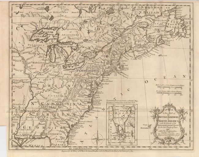
“A New Map of the British Dominions in North America; with the Limits of the Governments annexed thereto by the late Treaty of Peace, and settled by Proclamation, October 7th, 1763”
Map Maker:
Thomas Kitchin
This very historical map illustrates the British c... (full text available to subscribers)
| Item Detail |
| |
| |
MapMaker: |
Thomas Kitchin
|
|
| |
| |
Subject: |
Colonial United States and Canada |
|
| |
Period/Size: |
1763 / 9.4" x 11.8" (23.9 x 30.0 cm)
|
|
| |
Color: |
Black & White
|
|
| |
Condition: |
(A) This folding map has just a hint of offsetting, otherwise a fine example with dark, early impression. Close trimmed at top and bottom left for binding, as issued. Folded as issued. It is printed on hand laid paper with two circular watermarks. (condition help) |
|
| |
Source: |
Annual Register |
|
| |
References: |
McCorkle #763.5; Sellers & Van Ee 103; Jolly ANNREG-3. |
|
| |
|
|
| Sales Information |
| |
| |
Price: |
|
|
| |
| |
Offered by: |
Old World Auctions |
|
| |
Catalog: |
Auction No. 125 - Antique Maps, Charts, Atlases & Globes (654) |
|
| |
Lot/Item #: |
131 |
|
| |
| |
Date: |
09/2008
|
|
| |
| |
|
Antique Maps - Valuation and Pricing, Descriptions, Resources |
|
Home |
Information |
Search |
Register |
Contact Us |
Site Map
Americana Exchange, Inc. © 1999 - 2024 Americana Exchange, Inc.. All rights reserved.
OldMaps.com, the OldMaps.com logo and
AMPR are service marks or registered service marks of Americana Exchange, Inc..
|