Title:
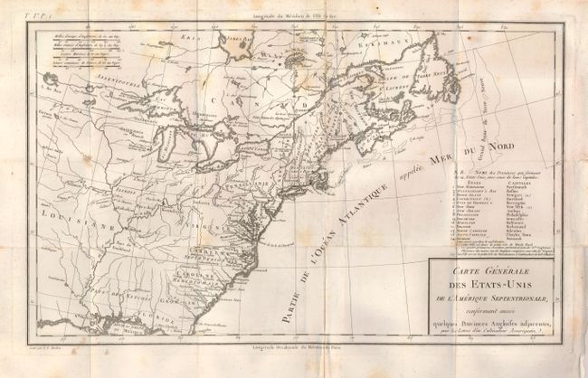
“Carte Generale des Etats-Unis de l'Amerique Septentrionale, Renfermant Aussi quelques Provinces Angloises adjacentes…”
Map Maker:
Pierre Francois Tardieu
This interesting map of the young United States is... (full text available to subscribers)
| Item Detail |
| |
| |
MapMaker: |
Pierre Francois Tardieu
|
|
| |
| |
Subject: |
Eastern United States |
|
| |
Period/Size: |
1787 / 9.8" x 16.3" (24.9 x 41.4 cm)
|
|
| |
Color: |
Black & White
|
|
| |
Condition: |
(B) Issued folded with an old paper repair along one fold. There is also some scattered foxing. (condition help) |
|
| |
Source: |
Les Lettres d'un Cultivateur Ameriquain |
|
| |
References: |
McCorkle #787.8; Mapforum 1, Checklist of Early Maps of the US #69; Baynton-Williams (TMC-72) #1. |
|
| |
|
|
| Sales Information |
| |
| |
Price: |
|
|
| |
| |
Offered by: |
Old World Auctions |
|
| |
Catalog: |
Auction No. 125 - Antique Maps, Charts, Atlases & Globes (654) |
|
| |
Lot/Item #: |
159 |
|
| |
| |
Date: |
09/2008
|
|
| |
| |
|
Antique Maps - Valuation and Pricing, Descriptions, Resources |
|
Home |
Information |
Search |
Register |
Contact Us |
Site Map
Americana Exchange, Inc. © 1999 - 2024 Americana Exchange, Inc.. All rights reserved.
OldMaps.com, the OldMaps.com logo and
AMPR are service marks or registered service marks of Americana Exchange, Inc..
|