Title:
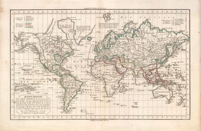
“Mappe-Monde ou Carte Generale de toutes les parties du Globe, corrigee et augmentee des Decouvertes du Cap. Cook, de celles de la Perouse en 1801, de Vancouver, de Mackensie en 1802, auxquelles sont ajoutees celles faites dans la Mer du Sud…”
Map Maker:
Charles Francois Delamarche
This copper engraved map of the world is drawn on ... (full text available to subscribers)
| Item Detail |
| |
| |
MapMaker: |
Charles Francois Delamarche
|
|
| |
| |
Subject: |
World |
|
| |
Period/Size: |
1795 / 9.4" x 15.3" (23.9 x 38.9 cm)
|
|
| |
Color: |
Colored
|
|
| |
Condition: |
(+B) Just a few light spots, otherwise a near fine example. Original hand coloring in outline and crisp impression. (condition help) |
|
| |
Source: |
|
|
| |
References: |
|
|
| |
|
|
| Sales Information |
| |
| |
Price: |
|
|
| |
| |
Offered by: |
Old World Auctions |
|
| |
Catalog: |
Auction No. 125 - Antique Maps, Charts, Atlases & Globes (654) |
|
| |
Lot/Item #: |
039 |
|
| |
| |
Date: |
09/2008
|
|
| |
| |
|
Antique Maps - Valuation and Pricing, Descriptions, Resources |
|
Home |
Information |
Search |
Register |
Contact Us |
Site Map
Americana Exchange, Inc. © 1999 - 2024 Americana Exchange, Inc.. All rights reserved.
OldMaps.com, the OldMaps.com logo and
AMPR are service marks or registered service marks of Americana Exchange, Inc..
|