Title:
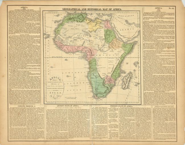
“Africa Drawn from the best Authorities for the Illustration of Lavoisne's Genealogical, Historical, Chronological & Geographical Atlas”
Map Maker:
Aspin/Lavoisne
Fine early nineteenth century map of the continent... (full text available to subscribers)
| Item Detail |
| |
| |
MapMaker: |
Aspin/Lavoisne
|
|
| |
| |
Subject: |
Africa |
|
| |
Period/Size: |
1821 / 11.3" x 11.5" (28.7 x 29.3 cm)
|
|
| |
Color: |
Colored
|
|
| |
Condition: |
(+B) Short split at lower centerfold into text and well away from map. Small portion of upper corners of margin missing, well away from neatline. (condition help) |
|
| |
Source: |
Lavoisone's Genealogical, Historical, Chronological & Geographical Atlas |
|
| |
References: |
cf Phillips (A) #5527. |
|
| |
|
|
| Sales Information |
| |
| |
Price: |
|
|
| |
| |
Offered by: |
Old World Auctions |
|
| |
Catalog: |
Auction No. 125 - Antique Maps, Charts, Atlases & Globes (654) |
|
| |
Lot/Item #: |
819 |
|
| |
| |
Date: |
09/2008
|
|
| |
| |
|
Antique Maps - Valuation and Pricing, Descriptions, Resources |
|
Home |
Information |
Search |
Register |
Contact Us |
Site Map
Americana Exchange, Inc. © 1999 - 2024 Americana Exchange, Inc.. All rights reserved.
OldMaps.com, the OldMaps.com logo and
AMPR are service marks or registered service marks of Americana Exchange, Inc..
|