Title:
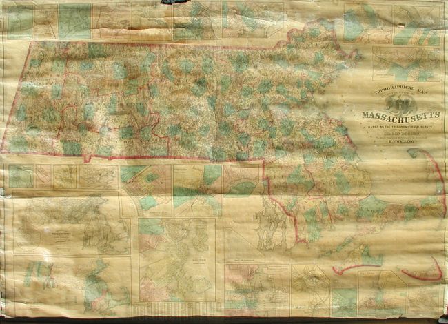
“Topographical Map of the State of Massachusetts Based on the Trigometrical Survey by Simeon Borden, The Details from Actual Surveys…”
Map Maker:
Henry Francis Walling
A beautifully engraved and handsome wall map that ... (full text available to subscribers)
| Item Detail |
| |
| |
MapMaker: |
Henry Francis Walling
|
|
| |
| |
Subject: |
Massachusetts |
|
| |
Period/Size: |
1861 / 55.0" x 74.5" (139.7 x 189.3 cm)
|
|
| |
Color: |
Colored
|
|
| |
Condition: |
(C) Clear varnish and both rollers attached. Area of loss at top center that affects about 3" of border and just touches the town plans of Lowell and Fitchburg. The map is loose from the lower roller on the right side. (condition help) |
|
| |
Source: |
|
|
| |
References: |
|
|
| |
|
|
| Sales Information |
| |
| |
Price: |
|
|
| |
| |
Offered by: |
Old World Auctions |
|
| |
Catalog: |
Auction No. 125 - Antique Maps, Charts, Atlases & Globes (654) |
|
| |
Lot/Item #: |
269 |
|
| |
| |
Date: |
09/2008
|
|
| |
| |
|
Antique Maps - Valuation and Pricing, Descriptions, Resources |
|
Home |
Information |
Search |
Register |
Contact Us |
Site Map
Americana Exchange, Inc. © 1999 - 2024 Americana Exchange, Inc.. All rights reserved.
OldMaps.com, the OldMaps.com logo and
AMPR are service marks or registered service marks of Americana Exchange, Inc..
|