Title:
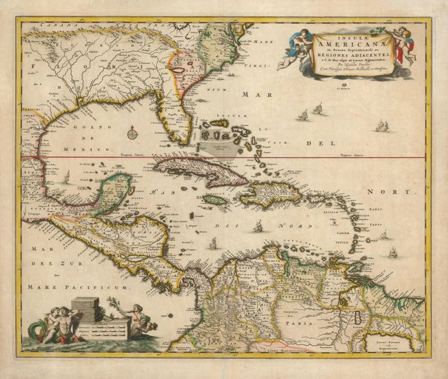
“Insulae Americanae in Oceano Septentrionali ac Regiones Adiacentes, a C. de May usque ad Lineam Aequinoctialem”
Map Maker:
Nicolas Visscher
This handsome map of focuses on the West Indies an... (full text available to subscribers)
| Item Detail |
| |
| |
MapMaker: |
Nicolas Visscher
|
|
| |
| |
Subject: |
Gulf of Mexico and Caribbean |
|
| |
Period/Size: |
1682 / 18.0" x 22.0" (45.8 x 55.9 cm)
|
|
| |
Color: |
Colored
|
|
| |
Condition: |
(+B) Lightly toned with a few darker spots and a repaired centerfold separation in the bottom quarter of the map. Paper edges are reinforced on verso. (condition help) |
|
| |
Source: |
Atlas Minor |
|
| |
References: |
Burden #531. |
|
| |
|
|
| Sales Information |
| |
| |
Price: |
|
|
| |
| |
Offered by: |
Old World Auctions |
|
| |
Catalog: |
Auction No. 125 - Antique Maps, Charts, Atlases & Globes (654) |
|
| |
Lot/Item #: |
346 |
|
| |
| |
Date: |
09/2008
|
|
| |
| |
|
Antique Maps - Valuation and Pricing, Descriptions, Resources |
|
Home |
Information |
Search |
Register |
Contact Us |
Site Map
Americana Exchange, Inc. © 1999 - 2024 Americana Exchange, Inc.. All rights reserved.
OldMaps.com, the OldMaps.com logo and
AMPR are service marks or registered service marks of Americana Exchange, Inc..
|