Title:
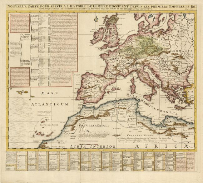
“Nouvelle Carte pour Servir a l'Histoire de l'Empire d'Occident Depuis les Premiers Empereurs Romains…”
Map Maker:
Henry Abraham Chatelain
This interesting map reflects the extent of the Ro... (full text available to subscribers)
| Item Detail |
| |
| |
MapMaker: |
Henry Abraham Chatelain
|
|
| |
| |
Subject: |
Europe and Mediterranean |
|
| |
Period/Size: |
1719 / 19.8" x 22.8" (50.3 x 58.0 cm)
|
|
| |
Color: |
Colored
|
|
| |
Condition: |
(A) Issued folding, now flattened with binding trim extended at lower left outside the plate mark. (condition help) |
|
| |
Source: |
Atlas Historique… |
|
| |
References: |
|
|
| |
|
|
| Sales Information |
| |
| |
Price: |
|
|
| |
| |
Offered by: |
Old World Auctions |
|
| |
Catalog: |
Auction No. 125 - Antique Maps, Charts, Atlases & Globes (654) |
|
| |
Lot/Item #: |
440 |
|
| |
| |
Date: |
09/2008
|
|
| |
| |
|
Antique Maps - Valuation and Pricing, Descriptions, Resources |
|
Home |
Information |
Search |
Register |
Contact Us |
Site Map
Americana Exchange, Inc. © 1999 - 2024 Americana Exchange, Inc.. All rights reserved.
OldMaps.com, the OldMaps.com logo and
AMPR are service marks or registered service marks of Americana Exchange, Inc..
|