Rister or Sign In to see pricing information


Title:

A New and Correct Chart from England to Guinea with all the Tradeing part of the West Indies…

Map Maker:

John Thornton

A New and Correct Chart from England to Guinea with all the Tradeing part of the West Indies…

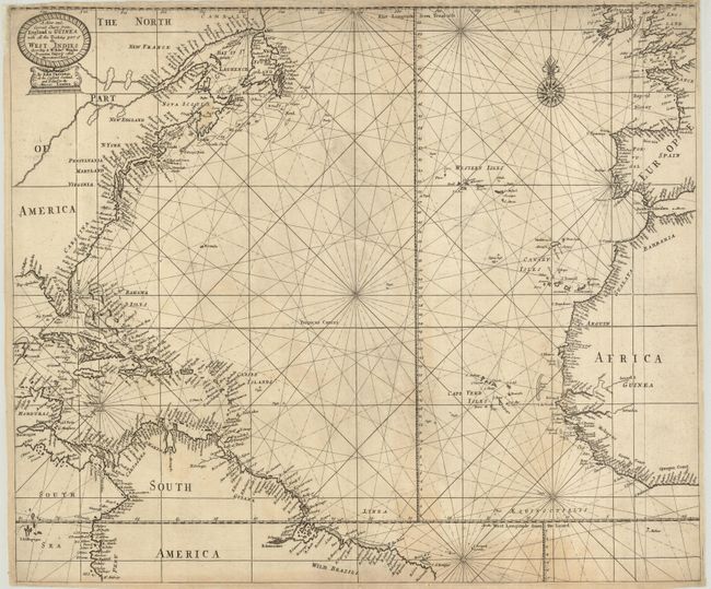
This scarce chart covers the North Atlantic and th... (full text available to subscribers)
Item Detail
 
  MapMaker:  

John Thornton


  Subject:  North Atlantic Ocean  
  Period/Size:  1689 / 18.5" x 22.0"  (47.0 x 55.9 cm)  
  Color:  Black & White  
  Condition:  (+B) Narrow, but adequate margins, as issued, with some edge tears repaired and backed with light Japanese tissue. (condition help)  
  Source:  A Sea Atlas (Atlas Maritimus)  
  References:   
 
 
Sales Information
 
  Price: 

Please register your email to view records, or sign in with email address to see records


  Offered by:  Old World Auctions  
  Catalog:  Auction No. 125 - Antique Maps, Charts, Atlases & Globes (654)  
  Lot/Item #:  426  
 
  Date:  09/2008  


Antique Maps - Valuation and Pricing, Descriptions, Resources


Home | Information | Search | Register | Contact Us | Site Map

Americana Exchange, Inc. © 1999 - 2024 Americana Exchange, Inc.. All rights reserved. OldMaps.com, the OldMaps.com logo and
AMPR are service marks or registered service marks of Americana Exchange, Inc..