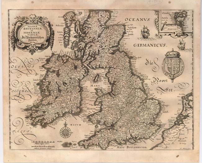
Title:
“Magnae Britanniae et Hiberniae Tabulae, Die Britannischen Insulen”
Map Maker:
Matthaus Merian
This handsome map of Britain is based on Blaeu's s... (full text available to subscribers)
| Item Detail |
| |
| |
MapMaker: |
Matthaus Merian
|
|
| |
| |
Subject: |
Britain |
|
| |
Period/Size: |
1650 / 10.6" x 14.0" (27.0 x 35.6 cm)
|
|
| |
Color: |
Black & White
|
|
| |
Condition: |
(+B) Nice impression with lightly toned paper and a couple of spots in the blank margins. (condition help) |
|
| |
Source: |
|
|
| |
References: |
Shirley [BI] #489. |
|
| |
|
|
| Sales Information |
| |
| |
Price: |
|
|
| |
| |
Offered by: |
Old World Auctions |
|
| |
Catalog: |
Auction No. 125 - Antique Maps, Charts, Atlases & Globes (654) |
|
| |
Lot/Item #: |
450 |
|
| |
| |
Date: |
09/2008
|
|
| |
| |
|
Antique Maps - Valuation and Pricing, Descriptions, Resources |
|
Home |
Information |
Search |
Register |
Contact Us |
Site Map
Americana Exchange, Inc. © 1999 - 2024 Americana Exchange, Inc.. All rights reserved.
OldMaps.com, the OldMaps.com logo and
AMPR are service marks or registered service marks of Americana Exchange, Inc..
|