Title:
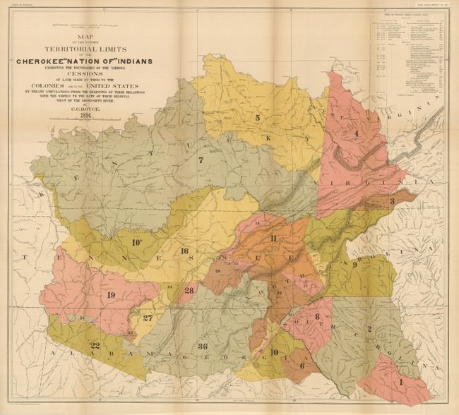
“Map of the Former Territorial Limits of the Cherokee Nation of Indians Exhibiting the Boundaries of the Various Cessions of Land…”
Map Maker:
Charles C. Royce
The title continues, "...Made by Them to the Colon... (full text available to subscribers)
| Item Detail |
| |
| |
MapMaker: |
Charles C. Royce
|
|
| |
| |
Subject: |
Southern United States |
|
| |
Period/Size: |
1884 / 28.3" x 31.5" (71.9 x 80.1 cm)
|
|
| |
Color: |
Colored
|
|
| |
Condition: |
(A) Folding as issued. Printed on thick paper with some fold splits as always seen on thick folded paper. One fold with very light toning, still very good. (condition help) |
|
| |
Source: |
5th Annual Report Bureau of Ethnology |
|
| |
References: |
|
|
| |
|
|
| Sales Information |
| |
| |
Price: |
|
|
| |
| |
Offered by: |
Old World Auctions |
|
| |
Catalog: |
Auction No. 126 - Antique Maps, Charts, Atlases & Globes (655) |
|
| |
Lot/Item #: |
190 |
|
| |
| |
Date: |
12/2008
|
|
| |
| |
|
Antique Maps - Valuation and Pricing, Descriptions, Resources |
|
Home |
Information |
Search |
Register |
Contact Us |
Site Map
Americana Exchange, Inc. © 1999 - 2024 Americana Exchange, Inc.. All rights reserved.
OldMaps.com, the OldMaps.com logo and
AMPR are service marks or registered service marks of Americana Exchange, Inc..
|