| Item Detail |
| |
| |
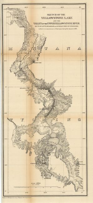
MapMaker: |
U.S. War Department
|
|
| |
| |
Subject: |
Montana, Wyoming, Yellowstone Park |
|
| |
Period/Size: |
1872 / 27.5" x 12.0" (69.9 x 30.5 cm)
|
|
| |
Color: |
Black & White
|
|
| |
Condition: |
(+B) Beautiful, dark impression. Toned along folds with archival tape on verso to support folds. (condition help) |
|
| |
Source: |
Sen. Ex. Doc. 66, 42nd Congress, 2nd Session |
|
| |
References: |
Blevins 225; Wheat 1220. |
|
| |
|
|
| Sales Information |
| |
| |
Price: |
|
|
| |
| |
Offered by: |
Old World Auctions |
|
| |
Catalog: |
Auction No. 126 - Antique Maps, Charts, Atlases & Globes (655) |
|
| |
Lot/Item #: |
307 |
|
| |
| |
Date: |
12/2008
|
|
| |
| |
|