Title:
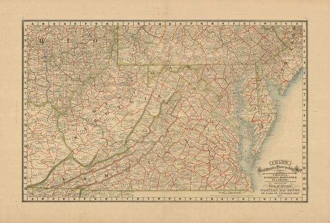
“Cram's Railroad & Township Map of Virginia, W. Virginia, Maryland & Delaware”
Map Maker:
George F. Cram [& Co.]
Rare map from the first edition of Cram's most cel... (full text available to subscribers)
| Item Detail |
| |
| |
MapMaker: |
George F. Cram [& Co.]
|
|
| |
| |
Subject: |
United States - Mid-Atlantic |
|
| |
Period/Size: |
1879 / 17.3" x 27.2" (44.0 x 69.1 cm)
|
|
| |
Color: |
Colored
|
|
| |
Condition: |
(A) Near fine example with beautiful hand coloring on a full sheet with very wide marigns. Long centerfold split expertly closed. (condition help) |
|
| |
Source: |
Cram's Standard American Atlas of the United States |
|
| |
References: |
Chicago Map Makers: "George F. Cram and the American Perception of Space" Gerald A. Danzer |
|
| |
|
|
| Sales Information |
| |
| |
Price: |
|
|
| |
| |
Offered by: |
Old World Auctions |
|
| |
Catalog: |
Auction No. 126 - Antique Maps, Charts, Atlases & Globes (655) |
|
| |
Lot/Item #: |
180 |
|
| |
| |
Date: |
12/2008
|
|
| |
| |
|
Antique Maps - Valuation and Pricing, Descriptions, Resources |
|
Home |
Information |
Search |
Register |
Contact Us |
Site Map
Americana Exchange, Inc. © 1999 - 2024 Americana Exchange, Inc.. All rights reserved.
OldMaps.com, the OldMaps.com logo and
AMPR are service marks or registered service marks of Americana Exchange, Inc..
|