Title:
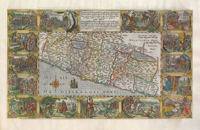
“Tabula Geographica, in qua Omnes Regiones, Urbes, oppida, loca et Fluvij Israeliae Describuntur”
Map Maker:
Plancius/Cloppenburg
This is one of the most decorative maps of Israel ... (full text available to subscribers)
| Item Detail |
| |
| |
MapMaker: |
Plancius/Cloppenburg
|
|
| |
| |
Subject: |
Holy Land |
|
| |
Period/Size: |
1643 / 11.5" x 19.5" (29.3 x 49.6 cm)
|
|
| |
Color: |
Colored
|
|
| |
Condition: |
(+B) The side margins of Bible maps are often damaged, as was the case with this map. They have been expertly restored using the leaf-casting method and the missing images in the bottom corners have been skillfully replaced. The restoration can only be (condition help) |
|
| |
Source: |
|
|
| |
References: |
Laor #567; Poortman & Augusteijn #78. |
|
| |
|
|
| Sales Information |
| |
| |
Price: |
|
|
| |
| |
Offered by: |
Old World Auctions |
|
| |
Catalog: |
Auction No. 126 - Antique Maps, Charts, Atlases & Globes (655) |
|
| |
Lot/Item #: |
683 |
|
| |
| |
Date: |
12/2008
|
|
| |
| |
|
Antique Maps - Valuation and Pricing, Descriptions, Resources |
|
Home |
Information |
Search |
Register |
Contact Us |
Site Map
Americana Exchange, Inc. © 1999 - 2024 Americana Exchange, Inc.. All rights reserved.
OldMaps.com, the OldMaps.com logo and
AMPR are service marks or registered service marks of Americana Exchange, Inc..
|