Rister or Sign In to see pricing information


Title:

Chart of Green Bay. Surveyed under the Direction of Capt. W.G. Williams… Reduced from the Original Map…

Map Maker:

U.S. War Department

Chart of Green Bay.  Surveyed under the Direction of Capt. W.G. Williams… Reduced from the Original Map…

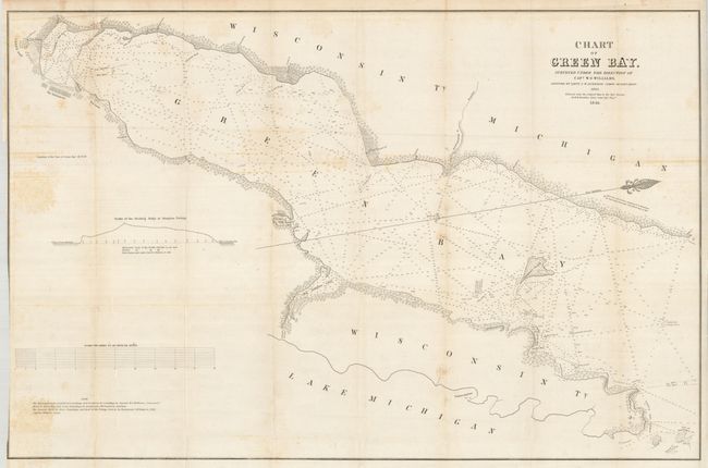
This large map describes the area from Ft. Howard ... (full text available to subscribers)
Item Detail
 
  MapMaker:  

U.S. War Department


  Subject:  Wisconsin, Green Bay  
  Period/Size:  1846 / 22.5" x 34.5"  (57.2 x 87.7 cm)  
  Color:  Black & White  
  Condition:  (+B) Binder's trim at left edge trimmed to neatline, as issued. A little occasional foxing, mostly on some folds. (condition help)  
  Source:   
  References:   
 
 
Sales Information
 
  Price: 

Please register your email to view records, or sign in with email address to see records


  Offered by:  Old World Auctions  
  Catalog:  Auction No. 126 - Antique Maps, Charts, Atlases & Globes (655)  
  Lot/Item #:  356  
 
  Date:  12/2008  


Antique Maps - Valuation and Pricing, Descriptions, Resources


Home | Information | Search | Register | Contact Us | Site Map

Americana Exchange, Inc. © 1999 - 2024 Americana Exchange, Inc.. All rights reserved. OldMaps.com, the OldMaps.com logo and
AMPR are service marks or registered service marks of Americana Exchange, Inc..