Title:
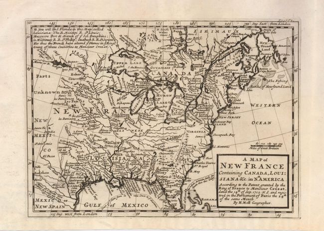
“A Map of New France Containing Canada, Louisiana &c. in Nth. America According to the Patent granted by the King of France to Monsieur Crozat, dated the 14th of Sep. 1712 N.S. and registered in the Parliament of Paris the 24th of the same Month”
Map Maker:
Herman Moll
This interesting map depicts the French possession... (full text available to subscribers)
| Item Detail |
| |
| |
MapMaker: |
Herman Moll
|
|
| |
| |
Subject: |
Colonial United States and Canada |
|
| |
Period/Size: |
1717 / 7.3" x 10.0" (18.6 x 25.4 cm)
|
|
| |
Color: |
Black & White
|
|
| |
Condition: |
(A) The impression is dark, but somewhat uneven in the Great Lakes region, else fine. (condition help) |
|
| |
Source: |
|
|
| |
References: |
McCorkle #717-1. |
|
| |
|
|
| Sales Information |
| |
| |
Price: |
|
|
| |
| |
Offered by: |
Old World Auctions |
|
| |
Catalog: |
Auction No. 126 - Antique Maps, Charts, Atlases & Globes (655) |
|
| |
Lot/Item #: |
120 |
|
| |
| |
Date: |
12/2008
|
|
| |
| |
|
Antique Maps - Valuation and Pricing, Descriptions, Resources |
|
Home |
Information |
Search |
Register |
Contact Us |
Site Map
Americana Exchange, Inc. © 1999 - 2024 Americana Exchange, Inc.. All rights reserved.
OldMaps.com, the OldMaps.com logo and
AMPR are service marks or registered service marks of Americana Exchange, Inc..
|