Title:
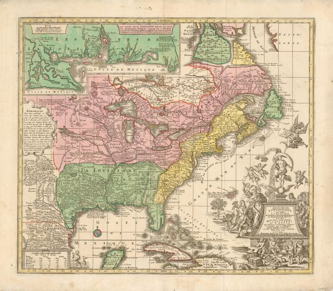
“Accurata delineatio celeberrimae Regionis Ludovicianae vel Gallice Louisiane ol Canadae et Floridae adpellatione in Septemtrionali America descripta quae hodie nomine fluminis Mississippi vel St. Louis…”
Map Maker:
Matthaus Seutter
This bold map of the eastern part of North America... (full text available to subscribers)
| Item Detail |
| |
| |
MapMaker: |
Matthaus Seutter
|
|
| |
| |
Subject: |
Colonial United States and Canada |
|
| |
Period/Size: |
1740 / 19.0" x 22.0" (48.3 x 55.9 cm)
|
|
| |
Color: |
Colored
|
|
| |
Condition: |
(A) Map image is near fine with strong impression and full coloring. The margins have a couple spots and a few short tears in left margin, one about 1.5" long, all clean. Some occasional roughness to paper edge. (condition help) |
|
| |
Source: |
|
|
| |
References: |
Portinaro & Knirsch #117. |
|
| |
|
|
| Sales Information |
| |
| |
Price: |
|
|
| |
| |
Offered by: |
Old World Auctions |
|
| |
Catalog: |
Auction No. 127 - Antique Maps, Charts, Atlases & Globes (678) |
|
| |
Lot/Item #: |
125 |
|
| |
| |
Date: |
02/2009
|
|
| |
| |
|
Antique Maps - Valuation and Pricing, Descriptions, Resources |
|
Home |
Information |
Search |
Register |
Contact Us |
Site Map
Americana Exchange, Inc. © 1999 - 2024 Americana Exchange, Inc.. All rights reserved.
OldMaps.com, the OldMaps.com logo and
AMPR are service marks or registered service marks of Americana Exchange, Inc..
|