Title:
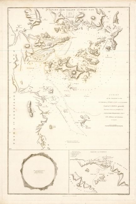
“A Chart of the Islands to the Southward of Tchu-San on the Eastern Coast of China Generally Laid Down from One Published by Alexander Dalrymple Esqre. with Additions and Alterations”
Map Maker:
Sir John Barrow
This is a finely executed chart of Zhoushan Harbor... (full text available to subscribers)
| Item Detail |
| |
| |
MapMaker: |
Sir John Barrow
|
|
| |
| |
Subject: |
China |
|
| |
Period/Size: |
1796 / 21.0" x 13.5" (53.4 x 34.3 cm)
|
|
| |
Color: |
Black & White
|
|
| |
Condition: |
(A) Map image is near fine on a full sheet of thick paper with wide margins. The margins have a little toning at edge and some binding stitch holes at left. In original uncolored state. (condition help) |
|
| |
Source: |
An Authentic Account of an Embassy from the King of Great Britainģ |
|
| |
References: |
|
|
| |
|
|
| Sales Information |
| |
| |
Price: |
|
|
| |
| |
Offered by: |
Old World Auctions |
|
| |
Catalog: |
Auction No. 127 - Antique Maps, Charts, Atlases & Globes (678) |
|
| |
Lot/Item #: |
709 |
|
| |
| |
Date: |
02/2009
|
|
| |
| |
|
Antique Maps - Valuation and Pricing, Descriptions, Resources |
|
Home |
Information |
Search |
Register |
Contact Us |
Site Map
Americana Exchange, Inc. © 1999 - 2024 Americana Exchange, Inc.. All rights reserved.
OldMaps.com, the OldMaps.com logo and
AMPR are service marks or registered service marks of Americana Exchange, Inc..
|