Title:
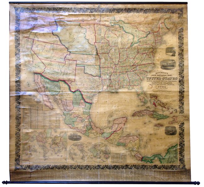
“Mitchell's New National Map, Exhibiting the United States with the North American British Provinces, Sandwich Islands, Mexico and Central America”
Map Maker:
Samuel Augustus Mitchell
A truly beautiful example of Mitchell's "New" map ... (full text available to subscribers)
| Item Detail |
| |
| |
MapMaker: |
Samuel Augustus Mitchell
|
|
| |
| |
Subject: |
North America |
|
| |
Period/Size: |
1857 / 65.0" x 63.0" (165.1 x 160.1 cm)
|
|
| |
Color: |
Colored
|
|
| |
Condition: |
(+B) Bright coloring and strong impression, varnish mostly clear and bright, just a little yellow toning. Hint of water stains at left corners. Surface is mostly unblemished with some cracking evident at upper edge near roller. The original green cloth (condition help) |
|
| |
Source: |
|
|
| |
References: |
|
|
| |
|
|
| Sales Information |
| |
| |
Price: |
|
|
| |
| |
Offered by: |
Old World Auctions |
|
| |
Catalog: |
Auction No. 127 - Antique Maps, Charts, Atlases & Globes (678) |
|
| |
Lot/Item #: |
101 |
|
| |
| |
Date: |
02/2009
|
|
| |
| |
|
Antique Maps - Valuation and Pricing, Descriptions, Resources |
|
Home |
Information |
Search |
Register |
Contact Us |
Site Map
Americana Exchange, Inc. © 1999 - 2024 Americana Exchange, Inc.. All rights reserved.
OldMaps.com, the OldMaps.com logo and
AMPR are service marks or registered service marks of Americana Exchange, Inc..
|