Title:
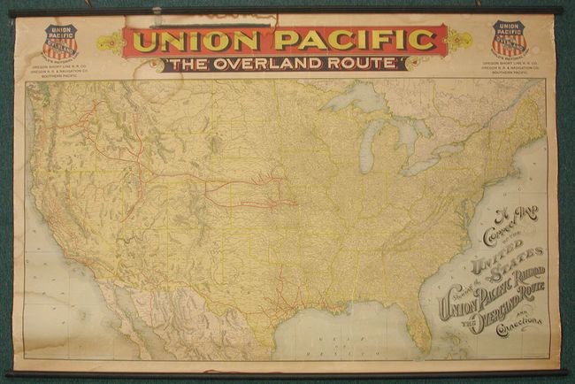
“A Correct Map of the United States Showing the Union Pacific Railroad. The Overland Route and Connections”
Map Maker:
Rand, McNally & Co.
A graphic wall map showing the United States with ... (full text available to subscribers)
| Item Detail |
| |
| |
MapMaker: |
Rand, McNally & Co.
|
|
| |
| |
Subject: |
United States |
|
| |
Period/Size: |
1896 / 35.0" x 53.5" (88.9 x 135.9 cm)
|
|
| |
Color: |
Colored
|
|
| |
Condition: |
(A) In remarkable condition for a map of this type with the original rails and vivid colors. There are a few damp stains, one of which caused the black paint of the rail to transfer to the top of the header above the map. There are a few minor cracks. (condition help) |
|
| |
Source: |
|
|
| |
References: |
|
|
| |
|
|
| Sales Information |
| |
| |
Price: |
|
|
| |
| |
Offered by: |
Old World Auctions |
|
| |
Catalog: |
Auction No. 127 - Antique Maps, Charts, Atlases & Globes (678) |
|
| |
Lot/Item #: |
168 |
|
| |
| |
Date: |
02/2009
|
|
| |
| |
|
Antique Maps - Valuation and Pricing, Descriptions, Resources |
|
Home |
Information |
Search |
Register |
Contact Us |
Site Map
Americana Exchange, Inc. © 1999 - 2024 Americana Exchange, Inc.. All rights reserved.
OldMaps.com, the OldMaps.com logo and
AMPR are service marks or registered service marks of Americana Exchange, Inc..
|