Title:
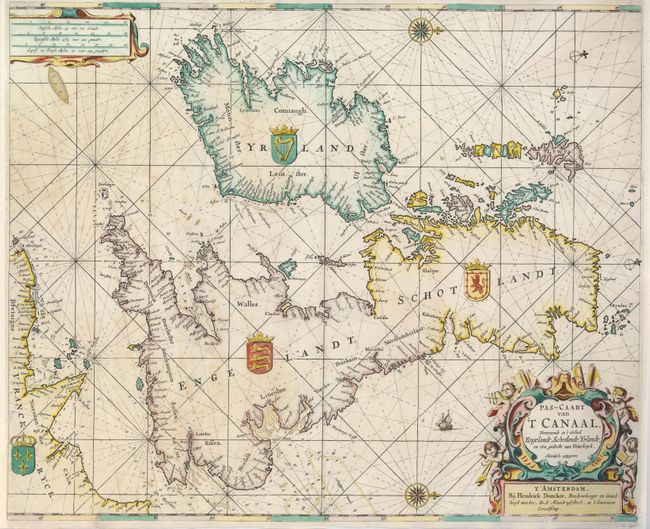
“Pas-Caart van 't Canaal, Vertoonende in 't Geheel Engelandt, Schotlandt, Yrlandt, en een Gedeelte van Vranckryck”
Map Maker:
Henrick Doncker
This is a very handsome sea-chart of the British I... (full text available to subscribers)
| Item Detail |
| |
| |
MapMaker: |
Henrick Doncker
|
|
| |
| |
Subject: |
Britain |
|
| |
Period/Size: |
1660 / 17.5" x 21.3" (44.5 x 54.1 cm)
|
|
| |
Color: |
Colored
|
|
| |
Condition: |
(A) The margins have been professionally extended to better accommodate framing, and the map is backed with light Japanese tissue repairing a couple minor tears near the centerfold. (condition help) |
|
| |
Source: |
Zee-Atlas |
|
| |
References: |
|
|
| |
|
|
| Sales Information |
| |
| |
Price: |
|
|
| |
| |
Offered by: |
Old World Auctions |
|
| |
Catalog: |
Auction No. 127 - Antique Maps, Charts, Atlases & Globes (678) |
|
| |
Lot/Item #: |
455 |
|
| |
| |
Date: |
02/2009
|
|
| |
| |
|
Antique Maps - Valuation and Pricing, Descriptions, Resources |
|
Home |
Information |
Search |
Register |
Contact Us |
Site Map
Americana Exchange, Inc. © 1999 - 2024 Americana Exchange, Inc.. All rights reserved.
OldMaps.com, the OldMaps.com logo and
AMPR are service marks or registered service marks of Americana Exchange, Inc..
|