Title:
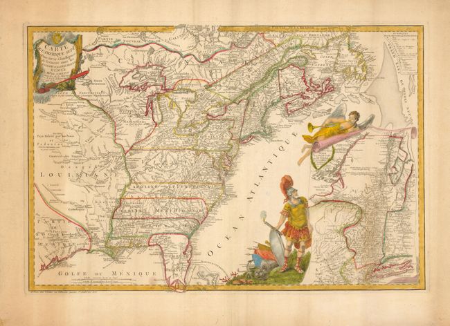
“Carte de l'Amerique Septle. Pour servir a l'Intelligence de la Guerre entre les Anglois et les Insurgents”
Map Maker:
Jean Chevalier de Beaurain
This extremely rare map covers the region from Jam... (full text available to subscribers)
| Item Detail |
| |
| |
MapMaker: |
Jean Chevalier de Beaurain
|
|
| |
| |
Subject: |
Colonial United States and Canada |
|
| |
Period/Size: |
1777 / 16.3" x 24.3" (41.4 x 61.8 cm)
|
|
| |
Color: |
Colored
|
|
| |
Condition: |
(B) There is toning along the sides of the map, heavier at the left. Otherwise it is in very good condition with sturdy paper. (condition help) |
|
| |
Source: |
|
|
| |
References: |
McCorkle #777.3; Sellers & Van Ee #149. |
|
| |
|
|
| Sales Information |
| |
| |
Price: |
|
|
| |
| |
Offered by: |
Old World Auctions |
|
| |
Catalog: |
Auction No. 127 - Antique Maps, Charts, Atlases & Globes (678) |
|
| |
Lot/Item #: |
134 |
|
| |
| |
Date: |
02/2009
|
|
| |
| |
|
Antique Maps - Valuation and Pricing, Descriptions, Resources |
|
Home |
Information |
Search |
Register |
Contact Us |
Site Map
Americana Exchange, Inc. © 1999 - 2024 Americana Exchange, Inc.. All rights reserved.
OldMaps.com, the OldMaps.com logo and
AMPR are service marks or registered service marks of Americana Exchange, Inc..
|