Title:
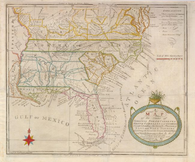
“A Map of the States of Virginia North Carolina South Carolina and Georgia Comprehending the Spanish Provinces of East and West Florida Exhibiting the Boundaries between the Unites States and Spanish Dominions as Fixed by the Treaty of Peace in 1783”
Map Maker:
Joseph Purcell
This fine map is a fascinating historical document... (full text available to subscribers)
| Item Detail |
| |
| |
MapMaker: |
Joseph Purcell
|
|
| |
| |
Subject: |
Southern United States |
|
| |
Period/Size: |
1793 / 12.5" x 14.8" (31.8 x 37.6 cm)
|
|
| |
Color: |
Colored
|
|
| |
Condition: |
(B) Issued folding, now flattened with a couple of fold intersections repaired on verso with tissue. The binding trim has been replaced at the lower left side and a 4" binding tear has been repaired. (condition help) |
|
| |
Source: |
Morse's American Universal Geography |
|
| |
References: |
Baynton-Williams (TMC-72] p. 15, #2.i; Sellers & Van Ee #1410; Wheat & Brun #494. |
|
| |
|
|
| Sales Information |
| |
| |
Price: |
|
|
| |
| |
Offered by: |
Old World Auctions |
|
| |
Catalog: |
Auction No. 127 - Antique Maps, Charts, Atlases & Globes (678) |
|
| |
Lot/Item #: |
202 |
|
| |
| |
Date: |
02/2009
|
|
| |
| |
|
Antique Maps - Valuation and Pricing, Descriptions, Resources |
|
Home |
Information |
Search |
Register |
Contact Us |
Site Map
Americana Exchange, Inc. © 1999 - 2024 Americana Exchange, Inc.. All rights reserved.
OldMaps.com, the OldMaps.com logo and
AMPR are service marks or registered service marks of Americana Exchange, Inc..
|