Rister or Sign In to see pricing information


Title:

Nouvelle Carte pour Servir a l'Histoire de l'Empire d'Orient depuis les Premiers Empereurs Romains…

Map Maker:

Henry Abraham Chatelain

Nouvelle Carte pour Servir a l'Histoire de l'Empire d'Orient depuis les Premiers Empereurs Romains…

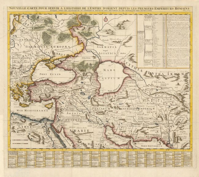
This map illustrates the extent of the Roman Empir... (full text available to subscribers)
Item Detail
 
  MapMaker:  

Henry Abraham Chatelain


  Subject:  Middle East  
  Period/Size:  1720 / 19.8" x 22.5"  (50.3 x 57.2 cm)  
  Color:  Colored  
  Condition:  (B) Issued folding, now flattened. There is a 3" long repaired tear in the upper left corner, else very good. (condition help)  
  Source:  Atlas Historique…  
  References:   
 
 
Sales Information
 
  Price: 

Please register your email to view records, or sign in with email address to see records


  Offered by:  Old World Auctions  
  Catalog:  Auction No. 127 - Antique Maps, Charts, Atlases & Globes (678)  
  Lot/Item #:  679  
 
  Date:  02/2009  


Antique Maps - Valuation and Pricing, Descriptions, Resources


Home | Information | Search | Register | Contact Us | Site Map

Americana Exchange, Inc. © 1999 - 2024 Americana Exchange, Inc.. All rights reserved. OldMaps.com, the OldMaps.com logo and
AMPR are service marks or registered service marks of Americana Exchange, Inc..