Title:
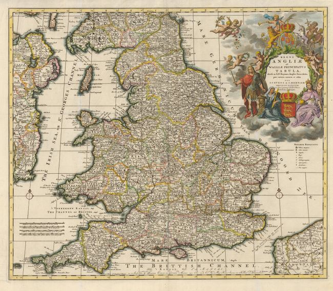
“Regni Angliae et Walliae Principatus Tabula…”
Map Maker:
Allard/Covens & Mortier
Handsome map of England and Wales, with large, ela... (full text available to subscribers)
| Item Detail |
| |
| |
MapMaker: |
Allard/Covens & Mortier
|
|
| |
| |
Subject: |
England & Wales |
|
| |
Period/Size: |
1735 / 19.8" x 23.3" (50.3 x 59.2 cm)
|
|
| |
Color: |
Colored
|
|
| |
Condition: |
(A+) Issued folding, now flattened. (condition help) |
|
| |
Source: |
|
|
| |
References: |
Shirley (BI) Allard 3, state 2. |
|
| |
|
|
| Sales Information |
| |
| |
Price: |
|
|
| |
| |
Offered by: |
Old World Auctions |
|
| |
Catalog: |
Auction No. 127 - Antique Maps, Charts, Atlases & Globes (678) |
|
| |
Lot/Item #: |
479 |
|
| |
| |
Date: |
02/2009
|
|
| |
| |
|
Antique Maps - Valuation and Pricing, Descriptions, Resources |
|
Home |
Information |
Search |
Register |
Contact Us |
Site Map
Americana Exchange, Inc. © 1999 - 2024 Americana Exchange, Inc.. All rights reserved.
OldMaps.com, the OldMaps.com logo and
AMPR are service marks or registered service marks of Americana Exchange, Inc..
|