Rister or Sign In to see pricing information


Title:

Mappa Geographica Regni Poloniae ex novissimis quot quot sunt mappis specialibus composita et ad LL. Sterographica projectionis revocata…

Map Maker:

Tobias Mayer

Mappa Geographica Regni Poloniae ex novissimis quot quot sunt mappis specialibus composita et ad LL. Sterographica projectionis revocata…

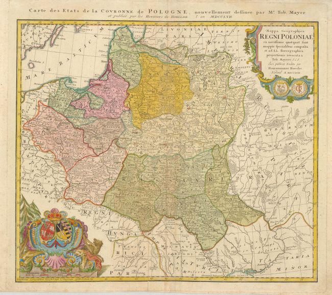
Johann Tobias Mayer's detailed map of the region b... (full text available to subscribers)
Item Detail
 
  MapMaker:  

Tobias Mayer


  Subject:  Poland  
  Period/Size:  1757 / 17.8" x 20.0"  (45.3 x 50.8 cm)  
  Color:  Colored  
  Condition:  (B) There is a large sheet of contemporary paper on the verso centerfold repairing some folds. (condition help)  
  Source:   
  References:  Buczek (Imago Mundi) p. 84, plate 42; Malinowski (MCC-25) #151.  
 
 
Sales Information
 
  Price: 

Please register your email to view records, or sign in with email address to see records


  Offered by:  Old World Auctions  
  Catalog:  Auction No. 127 - Antique Maps, Charts, Atlases & Globes (678)  
  Lot/Item #:  578  
 
  Date:  02/2009  


Antique Maps - Valuation and Pricing, Descriptions, Resources


Home | Information | Search | Register | Contact Us | Site Map

Americana Exchange, Inc. © 1999 - 2024 Americana Exchange, Inc.. All rights reserved. OldMaps.com, the OldMaps.com logo and
AMPR are service marks or registered service marks of Americana Exchange, Inc..