Title:
“De Stadt Ierusalem”
Map Maker:
Jan Barend Elwe
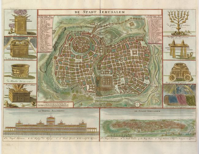
Great bird's-eye plan of the ancient holy city fla... (full text available to subscribers)
| Item Detail |
| |
| |
MapMaker: |
Jan Barend Elwe
|
|
| |
| |
Subject: |
Holy Land, Jerusalem |
|
| |
Period/Size: |
1791 / 13.5" x 19.8" (34.3 x 50.3 cm)
|
|
| |
Color: |
Colored
|
|
| |
Condition: |
(A+) (condition help) |
|
| |
Source: |
|
|
| |
References: |
Poortman & Augusteijn #162. |
|
| |
|
|
| Sales Information |
| |
| |
Price: |
|
|
| |
| |
Offered by: |
Old World Auctions |
|
| |
Catalog: |
Auction No. 128 - Antique Maps, Charts, Atlases & Globes (679) |
|
| |
Lot/Item #: |
799 |
|
| |
| |
Date: |
05/2009
|
|
| |
| |
|
Antique Maps - Valuation and Pricing, Descriptions, Resources |
|
Home |
Information |
Search |
Register |
Contact Us |
Site Map
Americana Exchange, Inc. © 1999 - 2024 Americana Exchange, Inc.. All rights reserved.
OldMaps.com, the OldMaps.com logo and
AMPR are service marks or registered service marks of Americana Exchange, Inc..
|