Title:
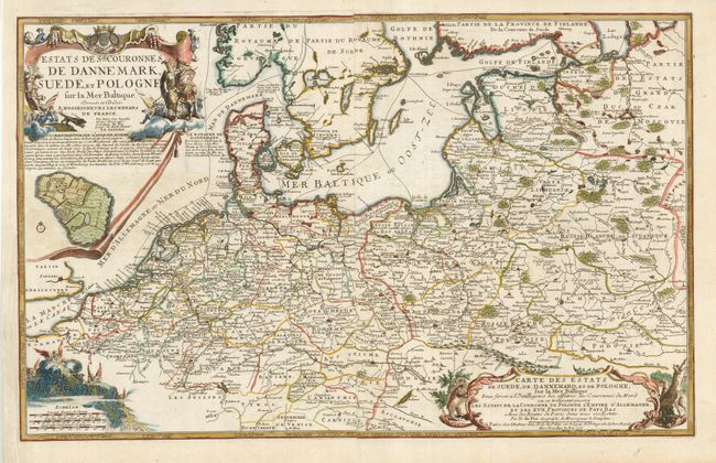
“Estats des Couronnes de Dannemark, Suede, et Pologna sur la Mer Baltique…”
Map Maker:
Nicolas de Fer
De Fer's two-sheet map of northern Europe. The ma... (full text available to subscribers)
| Item Detail |
| |
| |
MapMaker: |
Nicolas de Fer
|
|
| |
| |
Subject: |
Baltic |
|
| |
Period/Size: |
1705 / 17.5" x 27.8" (44.5 x 70.7 cm)
|
|
| |
Color: |
Colored
|
|
| |
Condition: |
(A+) The binding trim at lower left has been professionally extended to accommodate framing (condition help) |
|
| |
Source: |
|
|
| |
References: |
|
|
| |
|
|
| Sales Information |
| |
| |
Price: |
|
|
| |
| |
Offered by: |
Old World Auctions |
|
| |
Catalog: |
Auction No. 128 - Antique Maps, Charts, Atlases & Globes (679) |
|
| |
Lot/Item #: |
571 |
|
| |
| |
Date: |
05/2009
|
|
| |
| |
|
Antique Maps - Valuation and Pricing, Descriptions, Resources |
|
Home |
Information |
Search |
Register |
Contact Us |
Site Map
Americana Exchange, Inc. © 1999 - 2024 Americana Exchange, Inc.. All rights reserved.
OldMaps.com, the OldMaps.com logo and
AMPR are service marks or registered service marks of Americana Exchange, Inc..
|