Title:
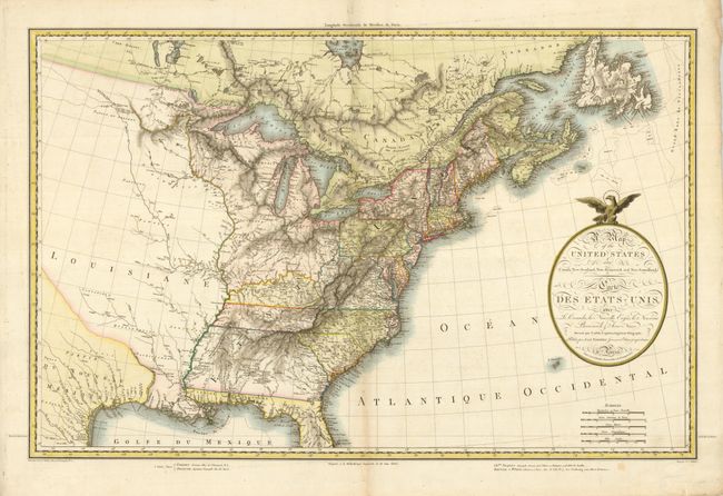
“A Map of the United States and Canada, New-Scotland, New-Brunswick and New-Foundland - Carte des Etats-Unis…”
Map Maker:
Lapie/Tardieu
This very uncommon map was drawn by Pierre Lapie, ... (full text available to subscribers)
| Item Detail |
| |
| |
MapMaker: |
Lapie/Tardieu
|
|
| |
| |
Subject: |
Eastern United States & Canada |
|
| |
Period/Size: |
1806 / 19.5" x 29.5" (49.6 x 75.0 cm)
|
|
| |
Color: |
Colored
|
|
| |
Condition: |
(A) Sharp impression and original color. Faintly toned on the centerfold with a couple minor extraneous folds. (condition help) |
|
| |
Source: |
|
|
| |
References: |
|
|
| |
|
|
| Sales Information |
| |
| |
Price: |
|
|
| |
| |
Offered by: |
Old World Auctions |
|
| |
Catalog: |
Auction No. 128 - Antique Maps, Charts, Atlases & Globes (679) |
|
| |
Lot/Item #: |
183 |
|
| |
| |
Date: |
05/2009
|
|
| |
| |
|
Antique Maps - Valuation and Pricing, Descriptions, Resources |
|
Home |
Information |
Search |
Register |
Contact Us |
Site Map
Americana Exchange, Inc. © 1999 - 2024 Americana Exchange, Inc.. All rights reserved.
OldMaps.com, the OldMaps.com logo and
AMPR are service marks or registered service marks of Americana Exchange, Inc..
|