Title:
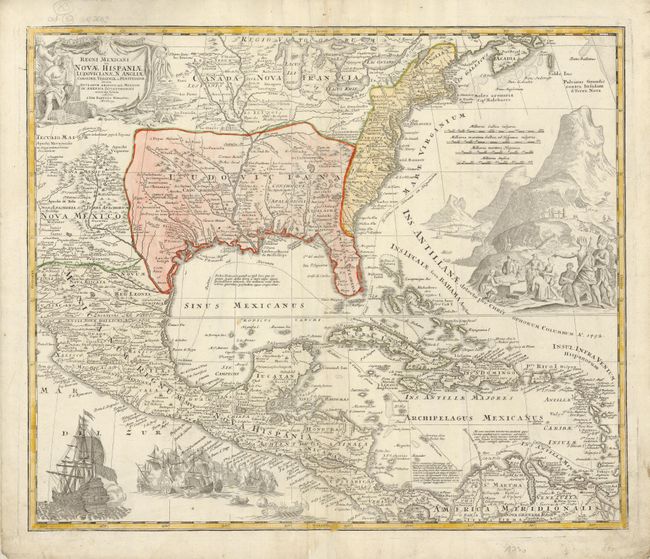
“Regni Mexicani seu Novae Hispaniae, Ludovicianae, N. Angliae, Carolinae, Virginiae, et Pensylvaniae nec non Insularum Archipelagi Mexicani in America Septentrionali Accurata Tabula…”
Map Maker:
Johann Baptist Homann
A superb map covering the region from the Great La... (full text available to subscribers)
| Item Detail |
| |
| |
MapMaker: |
Johann Baptist Homann
|
|
| |
| |
Subject: |
Colonial North America |
|
| |
Period/Size: |
1720 / 18.5" x 22.5" (47.0 x 57.2 cm)
|
|
| |
Color: |
Colored
|
|
| |
Condition: |
(A) Fine impression, original color on thick hand laid paper with original margins. Some creasing at centerfold, thinness along centerfold only visible when held to the light, and an old owner's or business stamp on verso with no show through to map. (condition help) |
|
| |
Source: |
|
|
| |
References: |
Van Ermen p.42; cf Cumming (SE) #137; Manasek #72; Martin & Martin plt.17. |
|
| |
|
|
| Sales Information |
| |
| |
Price: |
|
|
| |
| |
Offered by: |
Old World Auctions |
|
| |
Catalog: |
Auction No. 128 - Antique Maps, Charts, Atlases & Globes (679) |
|
| |
Lot/Item #: |
144 |
|
| |
| |
Date: |
05/2009
|
|
| |
| |
|
Antique Maps - Valuation and Pricing, Descriptions, Resources |
|
Home |
Information |
Search |
Register |
Contact Us |
Site Map
Americana Exchange, Inc. © 1999 - 2024 Americana Exchange, Inc.. All rights reserved.
OldMaps.com, the OldMaps.com logo and
AMPR are service marks or registered service marks of Americana Exchange, Inc..
|