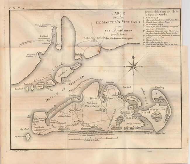
Title:
“Carte de l'Ile de Martha's Vineyard avec ses dependances…”
Map Maker:
Pierre Francois Tardieu
This is a rare copper engraved map covering Martha... (full text available to subscribers)
| Item Detail |
| |
| |
MapMaker: |
Pierre Francois Tardieu
|
|
| |
| |
Subject: |
Massachusetts |
|
| |
Period/Size: |
1787 / 8.3" x 10.3" (21.1 x 26.2 cm)
|
|
| |
Color: |
Black & White
|
|
| |
Condition: |
(+B) Folding as issued. Dark impression on thick hand laid paper with wide margins. Some light and diffuse foxing. Some very light offsetting that easily erases. (condition help) |
|
| |
Source: |
Lettres d'un Cultivateur Ameriqain |
|
| |
References: |
Phillips (M) p. 389; Howes No. C883 |
|
| |
|
|
| Sales Information |
| |
| |
Price: |
|
|
| |
| |
Offered by: |
Old World Auctions |
|
| |
Catalog: |
Auction No. 129 - Antique Maps, Charts, Atlases & Globes (680) |
|
| |
Lot/Item #: |
284 |
|
| |
| |
Date: |
09/2009
|
|
| |
| |
|
Antique Maps - Valuation and Pricing, Descriptions, Resources |
|
Home |
Information |
Search |
Register |
Contact Us |
Site Map
Americana Exchange, Inc. © 1999 - 2024 Americana Exchange, Inc.. All rights reserved.
OldMaps.com, the OldMaps.com logo and
AMPR are service marks or registered service marks of Americana Exchange, Inc..
|