Title:
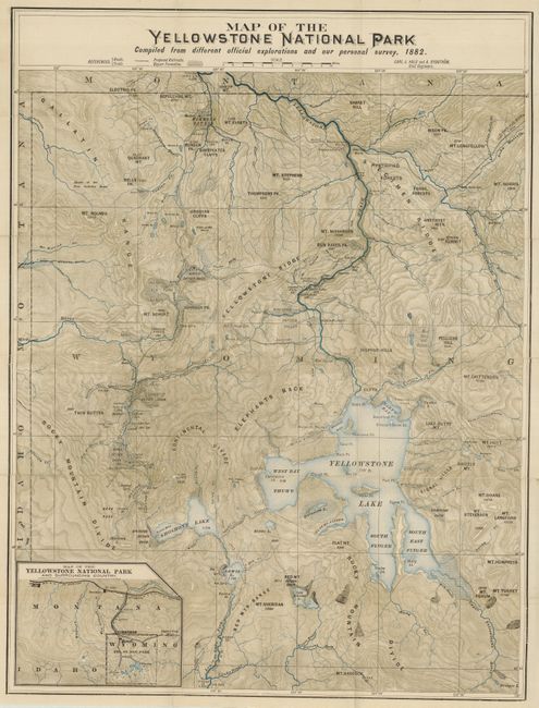
“Map of the Yellowstone National Park Compiled from Different Official Explorations and our Personal Survey, 1882”
Map Maker:
George Wood Wingate
This map was published 1886 by Carl J. Hals and A.... (full text available to subscribers)
| Item Detail |
| |
| |
MapMaker: |
George Wood Wingate
|
|
| |
| |
Subject: |
Wyoming, Yellowstone National Park |
|
| |
Period/Size: |
1886 / 24.0" x 18.0" (61.0 x 45.8 cm)
|
|
| |
Color: |
Colored
|
|
| |
Condition: |
(+B) The folding map has been backed with thin archival tissue to allow placement in rear pocket, but is starting to split along a couple fold lines - best to be stored flat. Rubbing to boards and wear to edges. Binding a bit weak but intact. Marginal s (condition help) |
|
| |
Source: |
Through the Yellowstone Park on Horseback |
|
| |
References: |
Blevins (Wyoming) No. 459. |
|
| |
|
|
| Sales Information |
| |
| |
Price: |
|
|
| |
| |
Offered by: |
Old World Auctions |
|
| |
Catalog: |
Auction No. 129 - Antique Maps, Charts, Atlases & Globes (680) |
|
| |
Lot/Item #: |
353 |
|
| |
| |
Date: |
09/2009
|
|
| |
| |
|
Antique Maps - Valuation and Pricing, Descriptions, Resources |
|
Home |
Information |
Search |
Register |
Contact Us |
Site Map
Americana Exchange, Inc. © 1999 - 2024 Americana Exchange, Inc.. All rights reserved.
OldMaps.com, the OldMaps.com logo and
AMPR are service marks or registered service marks of Americana Exchange, Inc..
|