Title:
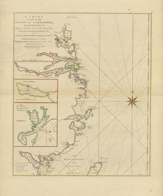
“A Chart of Part of the Coast of Labradore, from the Straights of Bell Isle, to Cape Bluff”
Map Maker:
Jefferys/Sayer & Bennett
This handsome chart shows the Labrador coast from ... (full text available to subscribers)
| Item Detail |
| |
| |
MapMaker: |
Jefferys/Sayer & Bennett
|
|
| |
| |
Subject: |
Canada |
|
| |
Period/Size: |
1770 / 21.5" x 18.0" (54.7 x 45.8 cm)
|
|
| |
Color: |
Colored
|
|
| |
Condition: |
(B) There is a large, professional paper restoration at upper left with the border and one letter in the title replaced in neat facsimile. There are old paper repairs on the fold, in the blank margins. (condition help) |
|
| |
Source: |
The North American Pilot |
|
| |
References: |
Sellers & Van Ee #685. |
|
| |
|
|
| Sales Information |
| |
| |
Price: |
|
|
| |
| |
Offered by: |
Old World Auctions |
|
| |
Catalog: |
Auction No. 129 - Antique Maps, Charts, Atlases & Globes (680) |
|
| |
Lot/Item #: |
124 |
|
| |
| |
Date: |
09/2009
|
|
| |
| |
|
Antique Maps - Valuation and Pricing, Descriptions, Resources |
|
Home |
Information |
Search |
Register |
Contact Us |
Site Map
Americana Exchange, Inc. © 1999 - 2024 Americana Exchange, Inc.. All rights reserved.
OldMaps.com, the OldMaps.com logo and
AMPR are service marks or registered service marks of Americana Exchange, Inc..
|