Title:
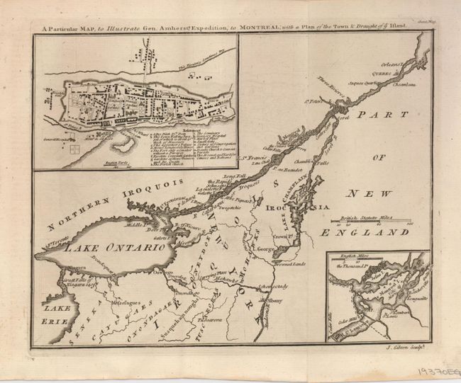
“A Particular Map, to Illustrate Gen. Amherst's Expedition, to Montreal; with a Plan of the Town & Draught of ye Island”
Map Maker:
John Gibson
After the fall of Quebec, Montreal was the sole re... (full text available to subscribers)
| Item Detail |
| |
| |
MapMaker: |
John Gibson
|
|
| |
| |
Subject: |
Colonial United States and Canada |
|
| |
Period/Size: |
1760 / 7.0" x 9.0" (17.8 x 22.9 cm)
|
|
| |
Color: |
Black & White
|
|
| |
Condition: |
(A) Faint stain at paper edge, well away from the map. (condition help) |
|
| |
Source: |
Gentleman's Magazine |
|
| |
References: |
Jolly GENT-145. |
|
| |
|
|
| Sales Information |
| |
| |
Price: |
|
|
| |
| |
Offered by: |
Old World Auctions |
|
| |
Catalog: |
Auction No. 129 - Antique Maps, Charts, Atlases & Globes (680) |
|
| |
Lot/Item #: |
138 |
|
| |
| |
Date: |
09/2009
|
|
| |
| |
|
Antique Maps - Valuation and Pricing, Descriptions, Resources |
|
Home |
Information |
Search |
Register |
Contact Us |
Site Map
Americana Exchange, Inc. © 1999 - 2024 Americana Exchange, Inc.. All rights reserved.
OldMaps.com, the OldMaps.com logo and
AMPR are service marks or registered service marks of Americana Exchange, Inc..
|