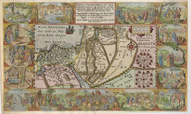
Title:
“Tabula Geographica, in Qua Iisraelitarum, ab Aegypto ad Kenahanaeam usque profectiones omnes, et stationes describuntur...”
Map Maker:
Plancius/Cloppenburg
This extremely decorative Bible map illustrates th... (full text available to subscribers)
| Item Detail |
| |
| |
MapMaker: |
Plancius/Cloppenburg
|
|
| |
| |
Subject: |
Holy Land |
|
| |
Period/Size: |
1604 / 11.5" x 19.3" (29.3 x 49.1 cm)
|
|
| |
Color: |
Colored
|
|
| |
Condition: |
(B) The impression in the map is a bit stronger than that of the vignettes. There is professional and very skillful paper restoration along the left side, with a bit of the corner replaced in facsimile. Part of the top and the left side margins have bee (condition help) |
|
| |
Source: |
|
|
| |
References: |
Laor #566; Poortman & Augusteijn #75. |
|
| |
|
|
| Sales Information |
| |
| |
Price: |
|
|
| |
| |
Offered by: |
Old World Auctions |
|
| |
Catalog: |
Auction No. 129 - Antique Maps, Charts, Atlases & Globes (680) |
|
| |
Lot/Item #: |
722 |
|
| |
| |
Date: |
09/2009
|
|
| |
| |
|
Antique Maps - Valuation and Pricing, Descriptions, Resources |
|
Home |
Information |
Search |
Register |
Contact Us |
Site Map
Americana Exchange, Inc. © 1999 - 2024 Americana Exchange, Inc.. All rights reserved.
OldMaps.com, the OldMaps.com logo and
AMPR are service marks or registered service marks of Americana Exchange, Inc..
|