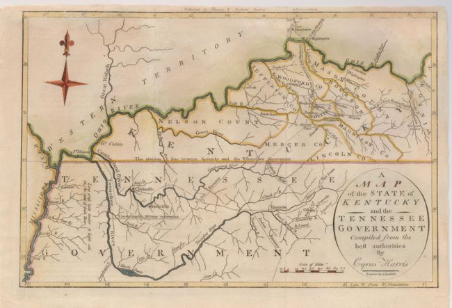
Title:
“A Map of the State of Kentucky and the Tennessee Government compiled from the Best Authorities by Cyrus Harris”
Map Maker:
Jedidiah Morse
This very early map shows some topographical featu... (full text available to subscribers)
| Item Detail |
| |
| |
MapMaker: |
Jedidiah Morse
|
|
| |
| |
Subject: |
Southern United States - Tennessee and Kentucky |
|
| |
Period/Size: |
1797 / 7.5" x 11.5" (19.1 x 29.3 cm)
|
|
| |
Color: |
Colored
|
|
| |
Condition: |
(+B) Some minor tears into the borders have been repaired. (condition help) |
|
| |
Source: |
Morse's Universal Geography |
|
| |
References: |
Wheat & Brun #645. |
|
| |
|
|
| Sales Information |
| |
| |
Price: |
|
|
| |
| |
Offered by: |
Old World Auctions |
|
| |
Catalog: |
Auction No. 129 - Antique Maps, Charts, Atlases & Globes (680) |
|
| |
Lot/Item #: |
212 |
|
| |
| |
Date: |
09/2009
|
|
| |
| |
|
Antique Maps - Valuation and Pricing, Descriptions, Resources |
|
Home |
Information |
Search |
Register |
Contact Us |
Site Map
Americana Exchange, Inc. © 1999 - 2024 Americana Exchange, Inc.. All rights reserved.
OldMaps.com, the OldMaps.com logo and
AMPR are service marks or registered service marks of Americana Exchange, Inc..
|