Title:
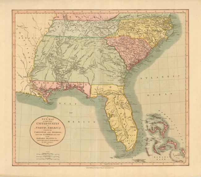
“A New Map of Part of the United States of North America, Containing the Carolinas and Georgia, also the Floridas and Part of the Bahama Islands &c. from the Latest Authorities”
Map Maker:
John Cary
This is a great map of the Southeast issued during... (full text available to subscribers)
| Item Detail |
| |
| |
MapMaker: |
John Cary
|
|
| |
| |
Subject: |
Southeastern United States |
|
| |
Period/Size: |
1811 / 18.3" x 20.5" (46.5 x 52.1 cm)
|
|
| |
Color: |
Colored
|
|
| |
Condition: |
(+B) Fine original color with a hint of faint offsetting. (condition help) |
|
| |
Source: |
New Universal Atlas |
|
| |
References: |
|
|
| |
|
|
| Sales Information |
| |
| |
Price: |
|
|
| |
| |
Offered by: |
Old World Auctions |
|
| |
Catalog: |
Auction No. 129 - Antique Maps, Charts, Atlases & Globes (680) |
|
| |
Lot/Item #: |
221 |
|
| |
| |
Date: |
09/2009
|
|
| |
| |
|
Antique Maps - Valuation and Pricing, Descriptions, Resources |
|
Home |
Information |
Search |
Register |
Contact Us |
Site Map
Americana Exchange, Inc. © 1999 - 2024 Americana Exchange, Inc.. All rights reserved.
OldMaps.com, the OldMaps.com logo and
AMPR are service marks or registered service marks of Americana Exchange, Inc..
|