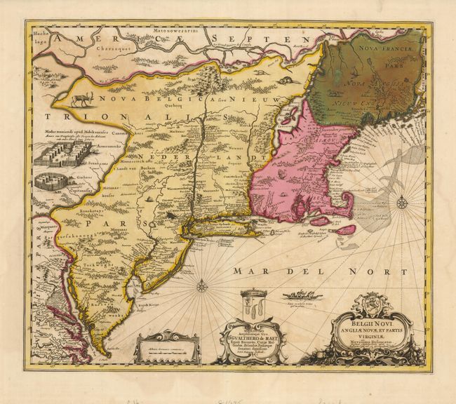
Title:
“Belgii Novi, Angliae Novae, et Partis Virginiae Novissima Delineatio”
Map Maker:
Jansson/Valk & Schenk
This great map is one of the fundamental landmark ... (full text available to subscribers)
| Item Detail |
| |
| |
MapMaker: |
Jansson/Valk & Schenk
|
|
| |
| |
Subject: |
Colonial New England and Mid Atlantic |
|
| |
Period/Size: |
1694 / 17.3" x 22.3" (44.0 x 56.7 cm)
|
|
| |
Color: |
Colored
|
|
| |
Condition: |
(+B) A nice impression with original color and very wide margins. At upper right in Nova Franciae Pars (New Brunswick) the green color has oxidized and has been reinforced on the verso to repair minor cracking. (condition help) |
|
| |
Source: |
|
|
| |
References: |
Burden #305; Fite & Freeman pp. 146-8; Tooley (Amer) p. 284, plt. #146. |
|
| |
|
|
| Sales Information |
| |
| |
Price: |
|
|
| |
| |
Offered by: |
Old World Auctions |
|
| |
Catalog: |
Auction No. 129 - Antique Maps, Charts, Atlases & Globes (680) |
|
| |
Lot/Item #: |
190 |
|
| |
| |
Date: |
09/2009
|
|
| |
| |
|
Antique Maps - Valuation and Pricing, Descriptions, Resources |
|
Home |
Information |
Search |
Register |
Contact Us |
Site Map
Americana Exchange, Inc. © 1999 - 2024 Americana Exchange, Inc.. All rights reserved.
OldMaps.com, the OldMaps.com logo and
AMPR are service marks or registered service marks of Americana Exchange, Inc..
|