Title:
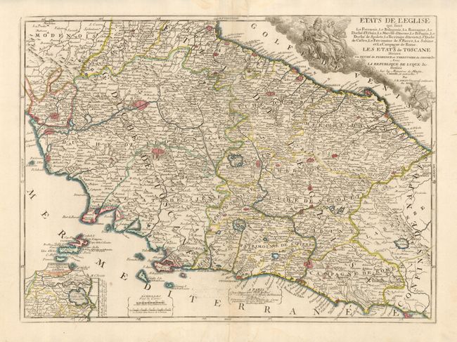
“Etats de l'Eglise qui sont le Ferrarois, le Bolognois, La Romagne, Le Duche d'Vrbain…”
Map Maker:
Jean Batiste Nolin
This is a rarely seen map of the Papal States deta... (full text available to subscribers)
| Item Detail |
| |
| |
MapMaker: |
Jean Batiste Nolin
|
|
| |
| |
Subject: |
Italy |
|
| |
Period/Size: |
1742 / 18.5" x 25.3" (47.0 x 64.3 cm)
|
|
| |
Color: |
Colored
|
|
| |
Condition: |
(+B) On thick hand laid paper with full margins and dark impression. Some old centerfold repairs on verso with one tiny hole in lower blank sea. Light water stain at lower centerfold bottom. (condition help) |
|
| |
Source: |
|
|
| |
References: |
|
|
| |
|
|
| Sales Information |
| |
| |
Price: |
|
|
| |
| |
Offered by: |
Old World Auctions |
|
| |
Catalog: |
Auction No. 130 - Antique Maps, Charts, Atlases & Globes (681) |
|
| |
Lot/Item #: |
617 |
|
| |
| |
Date: |
12/2009
|
|
| |
| |
|
Antique Maps - Valuation and Pricing, Descriptions, Resources |
|
Home |
Information |
Search |
Register |
Contact Us |
Site Map
Americana Exchange, Inc. © 1999 - 2024 Americana Exchange, Inc.. All rights reserved.
OldMaps.com, the OldMaps.com logo and
AMPR are service marks or registered service marks of Americana Exchange, Inc..
|