Title:
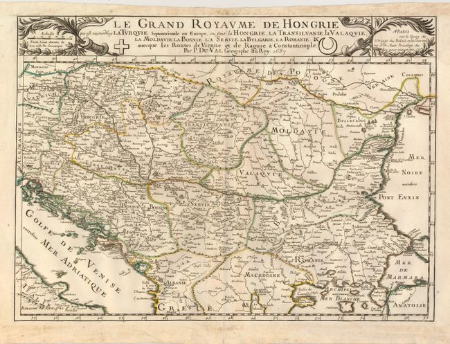
“Le Grand Royaume de Hongrie qui est Aujourdhuy la Turquie Septentrionale en Europe, ou sont la Hongrei, la Transilvanie, la Valaquie, la Moldavie, la Bosnie, la Servie, la Bulgarie, la Romanie…”
Map Maker:
Pierre Duval
Centered on the Danube River, the map covers the r... (full text available to subscribers)
| Item Detail |
| |
| |
MapMaker: |
Pierre Duval
|
|
| |
| |
Subject: |
Balkans |
|
| |
Period/Size: |
1687 / 15.3" x 21.0" (38.9 x 53.4 cm)
|
|
| |
Color: |
Colored
|
|
| |
Condition: |
(+B) Sharp impression with original outline color. There is some soil in the blank margin and some faint toning along the centerfold. (condition help) |
|
| |
Source: |
|
|
| |
References: |
|
|
| |
|
|
| Sales Information |
| |
| |
Price: |
|
|
| |
| |
Offered by: |
Old World Auctions |
|
| |
Catalog: |
Auction No. 130 - Antique Maps, Charts, Atlases & Globes (681) |
|
| |
Lot/Item #: |
593 |
|
| |
| |
Date: |
12/2009
|
|
| |
| |
|
Antique Maps - Valuation and Pricing, Descriptions, Resources |
|
Home |
Information |
Search |
Register |
Contact Us |
Site Map
Americana Exchange, Inc. © 1999 - 2024 Americana Exchange, Inc.. All rights reserved.
OldMaps.com, the OldMaps.com logo and
AMPR are service marks or registered service marks of Americana Exchange, Inc..
|