Title:
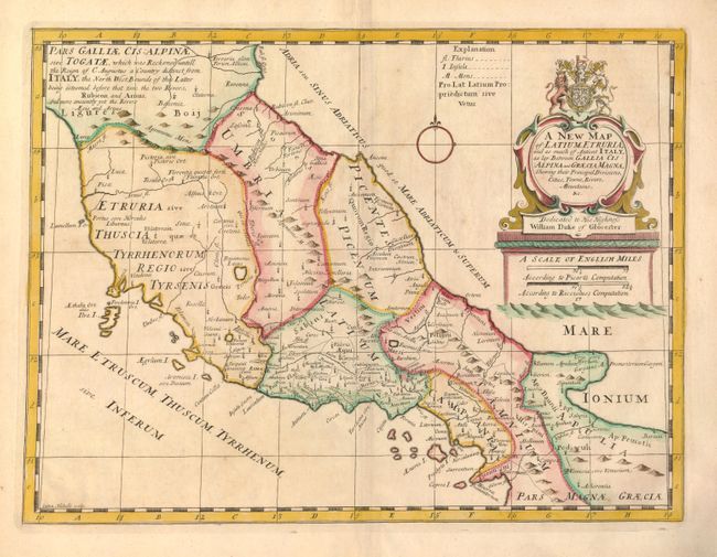
“A New Map of Latium, Etruria, and as much of Antient Italy, as lay Between Gallia Cisalpina and Graecia Magna, Shewing their Principal Divisions, Cities, Towns, Rivers Mountains &c.”
Map Maker:
Edward Wells
This map of central Italy shows the bounds of anci... (full text available to subscribers)
| Item Detail |
| |
| |
MapMaker: |
Edward Wells
|
|
| |
| |
Subject: |
Italy |
|
| |
Period/Size: |
1714 / 14.3" x 19.0" (36.4 x 48.3 cm)
|
|
| |
Color: |
Colored
|
|
| |
Condition: |
(A+) (condition help) |
|
| |
Source: |
A New Sett of Maps both of Antient and Present Geography |
|
| |
References: |
|
|
| |
|
|
| Sales Information |
| |
| |
Price: |
|
|
| |
| |
Offered by: |
Old World Auctions |
|
| |
Catalog: |
Auction No. 131 - Antique Maps, Charts, Atlases & Globes (682) |
|
| |
Lot/Item #: |
713 |
|
| |
| |
Date: |
02/2010
|
|
| |
| |
|
Antique Maps - Valuation and Pricing, Descriptions, Resources |
|
Home |
Information |
Search |
Register |
Contact Us |
Site Map
Americana Exchange, Inc. © 1999 - 2024 Americana Exchange, Inc.. All rights reserved.
OldMaps.com, the OldMaps.com logo and
AMPR are service marks or registered service marks of Americana Exchange, Inc..
|