Title:
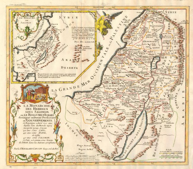
“La Monarchie des Hebreux sous Salomon, ou le Roiaume d'Israel distingue en Douze Prefectures ou Gouvernments”
Map Maker:
Pierre Moullart-Sanson
This scarce map depicts the Holy Land as it was du... (full text available to subscribers)
| Item Detail |
| |
| |
MapMaker: |
Pierre Moullart-Sanson
|
|
| |
| |
Subject: |
Holy Land |
|
| |
Period/Size: |
1717 / 13.8" x 15.7" (35.1 x 39.9 cm)
|
|
| |
Color: |
Colored
|
|
| |
Condition: |
(A) Near fine example less small trim to right corner and a light watermark in lower margin, not affecting the map. Fine, dark impression. (condition help) |
|
| |
Source: |
La Sainte Bible en latin et fracois |
|
| |
References: |
Laor #512. |
|
| |
|
|
| Sales Information |
| |
| |
Price: |
|
|
| |
| |
Offered by: |
Old World Auctions |
|
| |
Catalog: |
Auction No. 131 - Antique Maps, Charts, Atlases & Globes (682) |
|
| |
Lot/Item #: |
761 |
|
| |
| |
Date: |
02/2010
|
|
| |
| |
|
Antique Maps - Valuation and Pricing, Descriptions, Resources |
|
Home |
Information |
Search |
Register |
Contact Us |
Site Map
Americana Exchange, Inc. © 1999 - 2024 Americana Exchange, Inc.. All rights reserved.
OldMaps.com, the OldMaps.com logo and
AMPR are service marks or registered service marks of Americana Exchange, Inc..
|