Title:
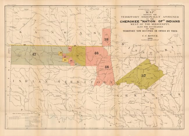
“Map of the Former Territorial Limits of the Cherokee "Nation of" Indians Exhibiting the Boundaries of the Various Cessions of Land … [in set with] Map Showing the Territory Originally Assigned to the Cherokee "Nation of" Indians West of the Mississippi”
Map Maker:
Charles C. Royce
A matched pair of important Cherokee Nation maps. ... (full text available to subscribers)
| Item Detail |
| |
| |
MapMaker: |
Charles C. Royce
|
|
| |
| |
Subject: |
Central United States |
|
| |
Period/Size: |
1884 / unknown
|
|
| |
Color: |
Colored
|
|
| |
Condition: |
(+B) Both folded as issued and printed on very thick paper. Both with just a hint of toning along some folds and a little weakness on some folds from the thickness of the paper, supported on verso with archival tape. (condition help) |
|
| |
Source: |
5th Annual Report Bureau of Ethnology |
|
| |
References: |
|
|
| |
|
|
| Sales Information |
| |
| |
Price: |
|
|
| |
| |
Offered by: |
Old World Auctions |
|
| |
Catalog: |
Auction No. 131 - Antique Maps, Charts, Atlases & Globes (682) |
|
| |
Lot/Item #: |
250 |
|
| |
| |
Date: |
02/2010
|
|
| |
| |
|
Antique Maps - Valuation and Pricing, Descriptions, Resources |
|
Home |
Information |
Search |
Register |
Contact Us |
Site Map
Americana Exchange, Inc. © 1999 - 2024 Americana Exchange, Inc.. All rights reserved.
OldMaps.com, the OldMaps.com logo and
AMPR are service marks or registered service marks of Americana Exchange, Inc..
|