Title:
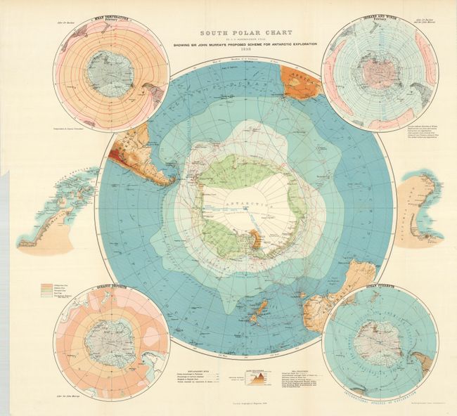
“South polar chart by J.G. Bartholomew, F.R.S.E. showing Sir John Murray’s proposed scheme for Antarctic exploration”
Map Maker:
John George Bartholomew
For the collector of Antarctica material this map ... (full text available to subscribers)
| Item Detail |
| |
| |
MapMaker: |
John George Bartholomew
|
|
| |
| |
Subject: |
South Pole |
|
| |
Period/Size: |
1898 / 20.8" x 22.2" (52.9 x 56.4 cm)
|
|
| |
Color: |
Colored
|
|
| |
Condition: |
(+B) The map is actually fine but has a 4" closed tear into the Isobars & Winds hemisphere at upper right. (condition help) |
|
| |
Source: |
Scottish Geographical Magazine |
|
| |
References: |
|
|
| |
|
|
| Sales Information |
| |
| |
Price: |
|
|
| |
| |
Offered by: |
Old World Auctions |
|
| |
Catalog: |
Auction No. 131 - Antique Maps, Charts, Atlases & Globes (682) |
|
| |
Lot/Item #: |
061 |
|
| |
| |
Date: |
02/2010
|
|
| |
| |
|
Antique Maps - Valuation and Pricing, Descriptions, Resources |
|
Home |
Information |
Search |
Register |
Contact Us |
Site Map
Americana Exchange, Inc. © 1999 - 2024 Americana Exchange, Inc.. All rights reserved.
OldMaps.com, the OldMaps.com logo and
AMPR are service marks or registered service marks of Americana Exchange, Inc..
|