Title:
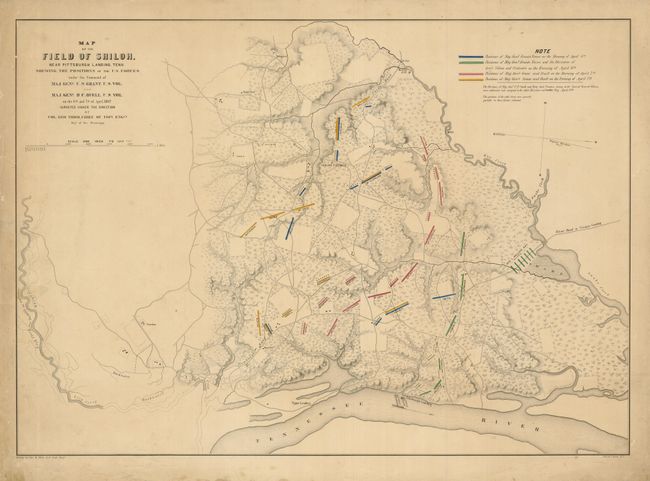
“Map of the Field of Shiloh, Near Pittsburgh Landing, Tenn. Shewing the Positions of the U.S. Forces under the Command of Maj. Genl. U.S. Grant U.S. Vol. And Maj. Genl. D.C. Buell, U.S. Vol. On the 6th and 7th of April 1862”
Map Maker:
U.S. War Department
This rare, separately issued Civil War battle m... (full text available to subscribers)
| Item Detail |
| |
| |
MapMaker: |
U.S. War Department
|
|
| |
| |
Subject: |
Tennessee |
|
| |
Period/Size: |
1866 / 17.3" x 24.5" (44.0 x 62.3 cm)
|
|
| |
Color: |
Colored
|
|
| |
Condition: |
(+B) The map image is very good, but the margins have several short tears, soiling, foxing and a crease across one corner. (condition help) |
|
| |
Source: |
|
|
| |
References: |
Rumsey #3658; Stephenson #437. |
|
| |
|
|
| Sales Information |
| |
| |
Price: |
|
|
| |
| |
Offered by: |
Old World Auctions |
|
| |
Catalog: |
Auction No. 131 - Antique Maps, Charts, Atlases & Globes (682) |
|
| |
Lot/Item #: |
321 |
|
| |
| |
Date: |
02/2010
|
|
| |
| |
|
Antique Maps - Valuation and Pricing, Descriptions, Resources |
|
Home |
Information |
Search |
Register |
Contact Us |
Site Map
Americana Exchange, Inc. © 1999 - 2024 Americana Exchange, Inc.. All rights reserved.
OldMaps.com, the OldMaps.com logo and
AMPR are service marks or registered service marks of Americana Exchange, Inc..
|