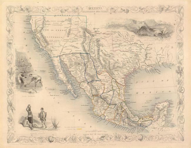
Title:
“Mexico, California and Texas”
Map Maker:
John Tallis
This is the second, and most desirable, state of t... (full text available to subscribers)
| Item Detail |
| |
| |
MapMaker: |
John Tallis
|
|
| |
| |
Subject: |
United States & Mexico |
|
| |
Period/Size: |
1850 / 10.0" x 13.0" (25.4 x 33.1 cm)
|
|
| |
Color: |
Colored
|
|
| |
Condition: |
(+B) The map image and coloring are fine with no flaws. In the past the map was paper backed and framed. The tips of the corners are trimmed in the blank margins and a mat burn surrounds the map outside of the image. Margins are more generous than ofte (condition help) |
|
| |
Source: |
Illustrated Atlas and Modern History of the World |
|
| |
References: |
Wheat (TMW) #694. |
|
| |
|
|
| Sales Information |
| |
| |
Price: |
|
|
| |
| |
Offered by: |
Old World Auctions |
|
| |
Catalog: |
Auction No. 131 - Antique Maps, Charts, Atlases & Globes (682) |
|
| |
Lot/Item #: |
394 |
|
| |
| |
Date: |
02/2010
|
|
| |
| |
|
Antique Maps - Valuation and Pricing, Descriptions, Resources |
|
Home |
Information |
Search |
Register |
Contact Us |
Site Map
Americana Exchange, Inc. © 1999 - 2024 Americana Exchange, Inc.. All rights reserved.
OldMaps.com, the OldMaps.com logo and
AMPR are service marks or registered service marks of Americana Exchange, Inc..
|