Title:
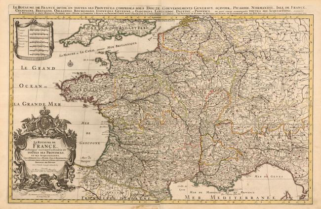
“Le Royaume de France Distingue Suivant l'Estendue de Toutes ses Provinces, et ses Acquisitions dans l'Espagne, dans l'Italie, dans l'Allemagne, et dans la Flandre, l'Artois, le Haynaut, le Namur, et le Luxembourg, Provinces des Pays-Bas”
Map Maker:
Alexis-Hubert Jaillot
Jaillot drew this superb, two-sheet, map of France... (full text available to subscribers)
| Item Detail |
| |
| |
MapMaker: |
Alexis-Hubert Jaillot
|
|
| |
| |
Subject: |
France |
|
| |
Period/Size: |
1696 / 22.8" x 35.0" (58.0 x 88.9 cm)
|
|
| |
Color: |
Colored
|
|
| |
Condition: |
(+B) Sharp impression and original outline color. The joint between the two sheets is separated at top in the blank margin, and at bottom just entering the border. (condition help) |
|
| |
Source: |
Atlas Nouveau |
|
| |
References: |
|
|
| |
|
|
| Sales Information |
| |
| |
Price: |
|
|
| |
| |
Offered by: |
Old World Auctions |
|
| |
Catalog: |
Auction No. 131 - Antique Maps, Charts, Atlases & Globes (682) |
|
| |
Lot/Item #: |
583 |
|
| |
| |
Date: |
02/2010
|
|
| |
| |
|
Antique Maps - Valuation and Pricing, Descriptions, Resources |
|
Home |
Information |
Search |
Register |
Contact Us |
Site Map
Americana Exchange, Inc. © 1999 - 2024 Americana Exchange, Inc.. All rights reserved.
OldMaps.com, the OldMaps.com logo and
AMPR are service marks or registered service marks of Americana Exchange, Inc..
|