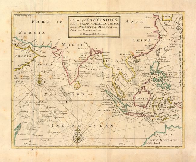
Title:
“A Chart of ye East-Indies, with the Coast of Persia, China also the Philipina, Moluca and Sunda Islands &c.”
Map Maker:
Herman Moll
This map covers the coastlines and islands from th... (full text available to subscribers)
| Item Detail |
| |
| |
MapMaker: |
Herman Moll
|
|
| |
| |
Subject: |
South East Asia |
|
| |
Period/Size: |
1717 / 10.8" x 13.8" (27.5 x 35.1 cm)
|
|
| |
Color: |
Colored
|
|
| |
Condition: |
(B) Nice impression with original color and some scattered foxing. (condition help) |
|
| |
Source: |
|
|
| |
References: |
|
|
| |
|
|
| Sales Information |
| |
| |
Price: |
|
|
| |
| |
Offered by: |
Old World Auctions |
|
| |
Catalog: |
Auction No. 131 - Antique Maps, Charts, Atlases & Globes (682) |
|
| |
Lot/Item #: |
835 |
|
| |
| |
Date: |
02/2010
|
|
| |
| |
|
Antique Maps - Valuation and Pricing, Descriptions, Resources |
|
Home |
Information |
Search |
Register |
Contact Us |
Site Map
Americana Exchange, Inc. © 1999 - 2024 Americana Exchange, Inc.. All rights reserved.
OldMaps.com, the OldMaps.com logo and
AMPR are service marks or registered service marks of Americana Exchange, Inc..
|