Rister or Sign In to see pricing information


Title:

Map of the Northern Part of the State of Maine and of the Adjacent British Provinces Shewing the Portion of that State to which Great Britain Lays Claim

Map Maker:

S.L. Dashiell

Map of the Northern Part of the State of Maine and of the Adjacent British Provinces Shewing the Portion of that State to which Great Britain Lays Claim

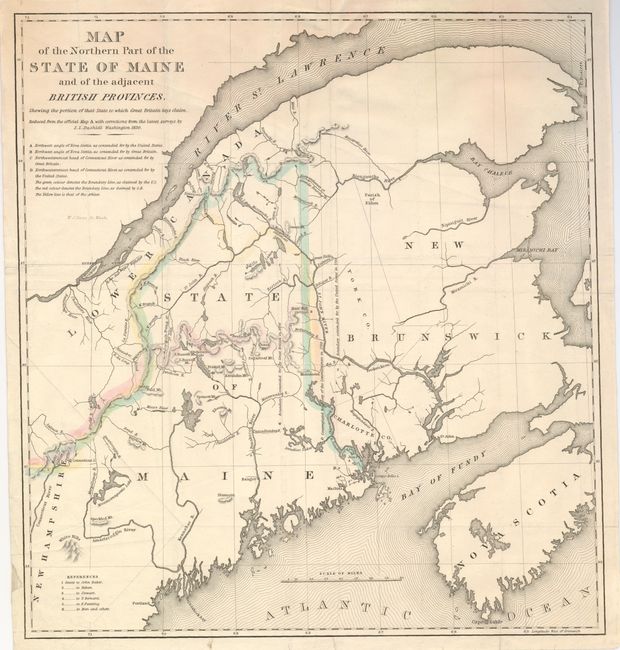
An interesting map that details the disputed bound... (full text available to subscribers)
Item Detail
 
  MapMaker:  

S.L. Dashiell


  Subject:  Maine  
  Period/Size:  1830 / 16.5" x 15.3"  (42.0 x 38.9 cm)  
  Color:  Colored  
  Condition:  (+B) Good impression with outline color. Issued folded, now pressed flat. A few paper reinforcements of folds on verso. (condition help)  
  Source:  SD 431., 25th Cong., 2d Sess.  
  References:   
 
 
Sales Information
 
  Price: 

Please register your email to view records, or sign in with email address to see records


  Offered by:  Old World Auctions  
  Catalog:  Auction No. 131 - Antique Maps, Charts, Atlases & Globes (682)  
  Lot/Item #:  323  
 
  Date:  02/2010  


Antique Maps - Valuation and Pricing, Descriptions, Resources


Home | Information | Search | Register | Contact Us | Site Map

Americana Exchange, Inc. © 1999 - 2024 Americana Exchange, Inc.. All rights reserved. OldMaps.com, the OldMaps.com logo and
AMPR are service marks or registered service marks of Americana Exchange, Inc..