Title:
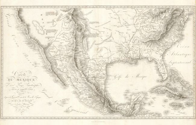
“Carte du Mexique et des Pays Limitrophes Situes au Nord et a l'Est Dressee d'apres la Grande Carte de la Nouvelle Espagne”
Map Maker:
Alexander von Humboldt
This is one of Alexander von Humboldt's important ... (full text available to subscribers)
| Item Detail |
| |
| |
MapMaker: |
Alexander von Humboldt
|
|
| |
| |
Subject: |
United States & Mexico |
|
| |
Period/Size: |
1811 / 16.6" x 28.5" (42.2 x 72.4 cm)
|
|
| |
Color: |
Black & White
|
|
| |
Condition: |
(+B) There is some light soil and faint foxing in the map. Narrow side margins ( 1/8") as issued. Fold separation in top margin has been repaired. (condition help) |
|
| |
Source: |
Essai Politique sur le Royaume de la Nouvelle Espagne |
|
| |
References: |
Cohen pp. 100-101; Wheat #275. |
|
| |
|
|
| Sales Information |
| |
| |
Price: |
|
|
| |
| |
Offered by: |
Old World Auctions |
|
| |
Catalog: |
Auction No. 131 - Antique Maps, Charts, Atlases & Globes (682) |
|
| |
Lot/Item #: |
384 |
|
| |
| |
Date: |
02/2010
|
|
| |
| |
|
Antique Maps - Valuation and Pricing, Descriptions, Resources |
|
Home |
Information |
Search |
Register |
Contact Us |
Site Map
Americana Exchange, Inc. © 1999 - 2024 Americana Exchange, Inc.. All rights reserved.
OldMaps.com, the OldMaps.com logo and
AMPR are service marks or registered service marks of Americana Exchange, Inc..
|